DC Metro Map, Navigating Washington, DC with Metro
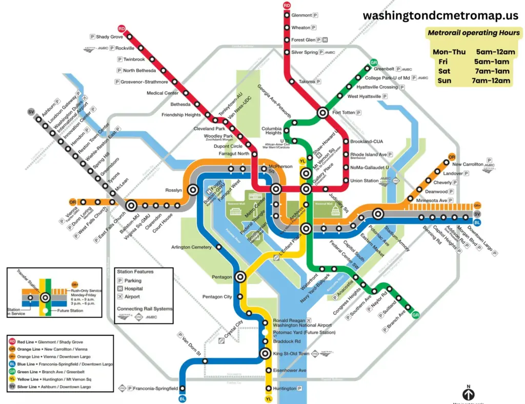
Washington DC’s metro system is the economical and convenient way of transportation for both locals and tourists to move around the nation’s capital, including Maryland and Virginia. If you are a visitor and want to get an overview of different metro stations and nearby tourist attractions such as the US Capitol Building, Washington Monument, National Mall, White House, etc., then you need an interactive metro map.
Here’s the updated version of the DC metro map. With this map, you can easily navigate around the city, plan your trips, and reach your final destination without getting lost. Let’s take a deep dive into the high-resolution Washington metro map with streets and explore its different routes and stations.
DC Metro Map, Click to Enlarge
Washington DC Metro Routes
DC Metro Blue Line
Provides services between Franconia–Springfield and Downtown Largo
DC Metro Red Line
Provides services between Shady Grove and Glenmont
DC Metro Orange Line
Provides services between Vienna and New Carrollton
DC Metro Yellow Line
Provides services between Huntington and MY Vernon SQ
DC Metro Green Line
Provides services between Branch Ave and Greenbelt
DC Metro Silver Line
Provides services between Downtown Largo and Ashburn
How Does the DC Metro Map Work?
The DC metro is the busiest transportation network, with over 355,000 weekday entries recorded by 2023, according to WMATA. The metro network consists of six color-coded lines similar to Riyadh metro map: Orange Line, Red Line, Silver Line, Blue Line, Green Line, and Yellow Line. There are a total of 98 stations indicated by small circles on the map, and 128 miles of track. Potomac Yard is the most recent station added to the metro network on May 19, 2023. Many stations are accessible by more than one line sharing track with each other. For example, if you are planning a visit to the White House, then the closest station to it is the Federal Triangle, accessible by three lines. The following table shows different lines sharing tracks between different stations.
| No. | Metro Lines | Share track Between |
| 1 | Orange and Silver | Court House Station and East Falls Church Station |
| 2 | Yellow and Blue | Pentagon Station and King Street Station |
| 3 | Blue and Silver | Benning Road Station and Largo Town Center Station |
| 4 | Yellow and Green | Fort Totten Station and L’Enfant Station |
| 5 | Blue, Orange and Silver | Rosslyn Station and Stadium-Armory Station |
Different metro lines are connected with the help of transfer stations(that allow you to change from one route to another), indicated by a double circle on the map. The metro network consists of 8 transfer stations. For example, to travel from Capital South station to the Zoo, you would need to take the silver, orange, or blue line to Metro Center station. From there, transfer to the red line and continue to the Zoo. Here’s the list of different transfer points:
While reading the map, the line on the top of the other lines shows it is physically on the top floor. For example, at the Metro Center station, the red line is upstairs and the blue, silver, and orange lines are downstairs. WATMA metro trip planner is the most convenient way to plan your trip around the capital. The other transit networks are easily accessible by Metrorail, including Dulles International Airport, Ronald Reagan Washington National Airport, Baltimore Washington International Airport, and train services like MARC and Amtrak.
The following video will further guide you on how to read the DC Metro Map. Video credit: Trip Hack
Washington DC Metrorail Time Schedule
Metro trains run every day, but the timing may vary depending on specific lines and weekdays. However, in case of public holidays and special events, the metro’s regular operating schedule is modified. The Metrorail stops running at 12 AM, except on Fridays and Saturdays when it runs until 1 AM. The following table shows the rail hours for the whole week:
| Day | Time |
| Monday-Thursday | 5 am-12 am |
| Friday | 5 am-1 am |
| Saturday | 7 am-1 am |
| Sunday | 7 am-12 am |
Now, how much the fare will be between the Washington DC metro stations? If I want to travel from Metro Center station to Rosslyn station, how much will it cost? The cost of the ticket depends on the length of the ride, the time you ride, and the day of the week. For details information about metro fares and how to buy tickets visit the page Fare and Tickets.
In this article, we comprehensively covered everything about the Washington DC Metro Map, which will help you in navigating the capital and planning your trips during your stay. We recommend using our interactive metro map during your journey and downloading a copy of the DC metro map on your phone. If you have any questions don’t forget to comment.

